What is a Continental Divide?
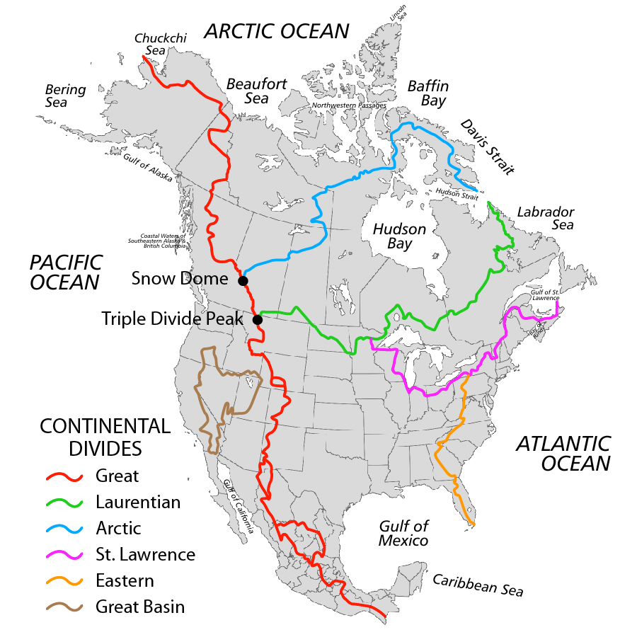
Principal Continental Divides of North America. Created by Pfly/Wikimedia CC.
We all know that water runs downhill, but when we look at the topography of an entire continent, not all water will flow to the same point. The continental divides are boundaries or ridges that separate continental drainage basins, and mark the tipping point on which direction water will flow. In other words, if water falls on one side of the line, it will likely flow in one direction, and end up at the end point for that drainage basin. Water falling to the other side of the line will likely end up at different drainage basin’s end point. These end points are normally oceans or seas. Overall, continental divides act as large scale borders for large scale watersheds/drainage basins. Want to learn more about watersheds in particular? Check out our factsheet and blog about them.

Source: https://www.ec.gc.ca/eaudouce-freshwater/default.asp?lang=en&n=D72B6AF9-1
Continental Divides in Alberta
In Alberta there are actually three continental divides:
The Great Divide, otherwise known as THE continental divide, it is the most commonly referred to divide in our province. It runs mainly in a north/south direction, with significant sections of it being in the Rocky Mountains following the Alberta/British Columbia border. This means that water to the west of this line is likely to flow to west to the Pacific Ocean, while water falling to the east is likely to mostly flow east and north to either the Arctic Ocean or Hudson’s Bay.
The Laurentian Divide is a second continental divide in Alberta. It runs through southern Alberta in an east/west direction. On a larger scale, it spans from Montana to Labrador. Water to north of this line will mostly flow eventually to Hudson’s Bay, while water to the south of this line in Canada will flow to the Great Lakes- St. Lawrence River Basin.
The Arctic Divide is the last of the continental divides in Alberta. This is one that runs very close to Edmonton. It begins in the Rocky mountains, at the Great Divide, and heads east and north. Water to the north of this line will end up in the Arctic Ocean, hence the divides name. Whereas water to the south of this line will flow to Hudson’s Bay.
North of the Arctic Divide
The water that flows north of the Arctic Divide, can actually be sub-divided into 3 different smaller watersheds or drainage/river basins. The Hay River, Peace/Slave River, and Athabasca River.
South of the Arctic Divide
This area of the divide, which reaches down to the Laurentian Divide, encompasses both the North and South Saskatchewan River Basins

The Arctic Divide: Close to Home
One of the Edmonton and Area Land Trust’s conservation areas runs very close to the Arctic Continental Divide. Lu Carbyn Nature Sanctuary, which is located near the Lily Lake Natural Area west of Edmonton, falls just north of the Arctic Divide. The significance of this is that water only a few kilometers south of this property will more than likely wind up in a very different location that water flowing from the Sanctuary. Read more about this unique conservation land.

Lu Carbyn Nature Sanctuary
Determining Continental Divide Lines
You may be wondering, why is this the first I’m hearing about this continental divide? Well here are some contributing factors:
Divides are very long imaginary lines that cross many different parcels of land. They are not just one single point on a map.
Our landscape, especially here in central Alberta, is a constantly changing one. This means that the topography and hydrology of flowing water changes from year to year as human and natural impacts are constantly modifying the land, and therefore the divide line also shifts.
Although you can find general divide line maps (i.e. full map of Canada), the exact zoomed in location of these lines are generally not displayed on public websites. It takes looking at research sources (i.e. Government of Canada) with hydrological data showing watershed boundaries and water flow directions. This can then be compared to other research sources and different years to determine the best approximation of the line through a specific area.
Fun Facts!
The only continent without a continental divide is Antarctica
The “Snow Dome” is the term used to refer to where the Arctic and Great Divide meet in the Rocky Mountains.
The Great Divide, also called “Continental Divide of the America’s” spans nearly the whole length of North and South America
External Sources
Dutil-ricard, L., & Finlayson, D. (2017, November 28). Continental Divides in Canada. Retrieved from The Canadian Encyclopedia: https://www.thecanadianencyclopedia.ca/en/article/continental-divide
Government of Canada. (2019). Open Maps Data Viewer. Retrieved from Government of Canada: https://open.canada.ca/data/en/fgpv_vpgf/a4b190fe-e090-4e6d-881e-b87956c07977